
An Unusual Twist To Heavy Flooding, or How To Find A Parking Place For 9 Billion Gallons of Water
I do not typically write about things local to me. Others, like my friend Ted Shideler, do it so much better and more thoroughly than I ever could. However. Sometimes a local story comes along that grabs me by the lapels and will not let go. One of them involves the recent flooding in Central Indiana, and an unexpected safety valve that prevented it from being worse.
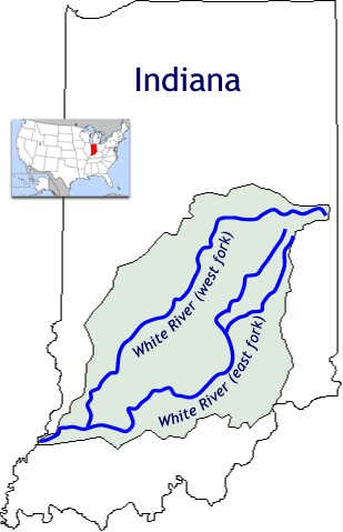
Much has been written about the major flooding that Central Indiana experienced last month. On August 11th, hours of heavy rain began to wallop the already saturated central northeast part of the state, mainly along the corridor of the White River. Indianapolis is in the geographic center of the state, and was located there (it is said) in the mistaken belief that the White River was a navigable connector between the Great Lakes to the north and the Ohio River at the State’s southern border. They were wrong – the White River1 does indeed flow into the Wabash River and then the Ohio River to the south, but following either of its forks to the north gets you only into innumerable small creeks and streams in Randolph County, along the State’s eastern border. But from Muncie and to its south, the White River is a major source of fresh water that gets bigger as it goes south.
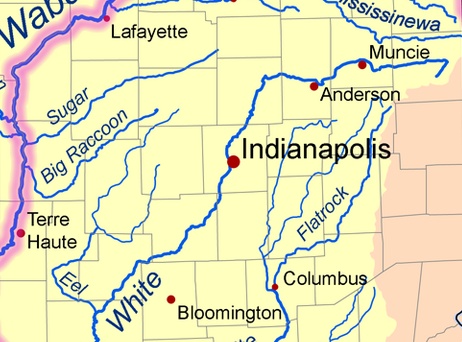
The rain that fell on August 11th was at its worst in the areas of two county seat cities to Indianapolis’ northeast (Anderson and Muncie), which were drenched with rainfall of over 11 inches in two days. New Castle, just east of Muncie recorded a one-in-1000-year rainfall of 11 inches in 32 hours. And with so much rain concentrated in the vicinity of the White River, you know what happened next.
The river at Muncie crested at 18.64 feet (over 9.5 feet above flood stage), though short of its 1913 record of over 22 feet.2 (Blogger Ted Shideler documented some of the damage there.) Anderson, the next decent sized city downstream from Muncie broke the 1913 record with a crest of nearly 25 feet, or about 15 feet above flood stage. Even though the river widens as it goes south, Noblesville (about halfway downriver between Anderson and Indianapolis) still broke the 1913 record with over 24 feet (more than 10 feet over flood stage). History and experience tells us that heavy rains flood the river and that those floods continue to build momentum as they course downriver through city after city. But this is where the story of 2026 saw an interesting twist.
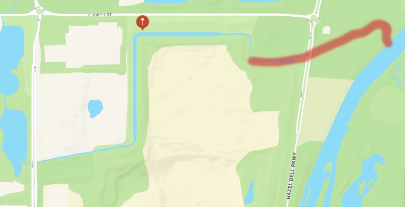
There is a small creek called Blue Woods Creek that meanders around until it empties into the White River south of Noblesville and not far above the northern edge of the Indianapolis Metropolitan Area. About thirty years ago, that creek was redirected around the northern edge of a large sand and gravel quarry operated by Martin Marietta. Between the quarry and the river, a road called Hazel Dell Parkway was built over it in an area that has experienced explosive residential and commercial growth in that time. What does this have to do with the flood? Just this: The quickly rising river levels caused water to flow backwards up Blue Woods Creek. It rose under the Hazel Dell Parkway bridge and, as water volume continued to rise, it found its way to the edge of the quarry.
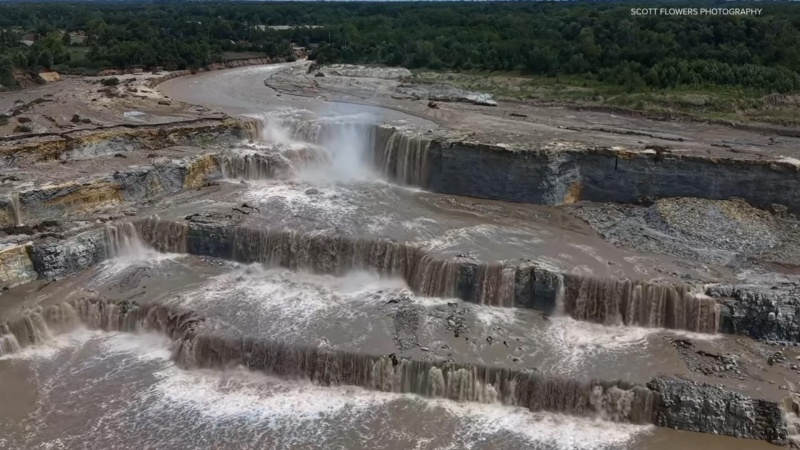
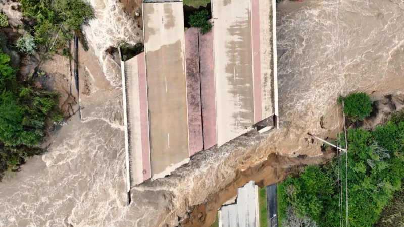
Once that flow was established, the power of moving water manifested itself. The water dug deeper and wider as it kept backflushing up the creek in ever greater volumes. And when it came to the sharp northward bend, the powerful current had a better idea and pushed straight into the quarry, where it created some impressive waterfalls as it slowly began to fill the quarry (and some tunnel mines under it). A fellow with a drone captured some of the drama (link here), including the way the supercharged creek destroyed the Hazel Dell Parkway bridge.
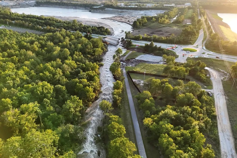
By August 17th, six days after the bulk of the rainfall, the swollen river continued emptying into the quarry. In fact, there were fears that without drastic intervention, the force of the water would finish cutting a new mouth into the white river, which could very well have turned the quarry into a permanent reservoir. How big of a reservoir? Officials estimated that the quarry was nearing a capacity that they estimated at 9 billion gallons. That is Billion, with a B.
With resources from the City of Carmel, Hamilton County, the State of Indiana and the Army Corps of Engineers, helicopters worked with helicopters to drop concrete and sandbags as temporary dams to keep the river within its (engorged) banks. The next problem is what do do with the 9 billion gallons of water. It will have to go back into the river, but it is estimated that the process will take about 90 days.
Of course, it was not sunshine and roses for everyone, because Martin-Marietta took one for the team. Not only do they have to oversee the work of draining the quarry and trying to remove/salvage the machinery at the bottom of this temporary lake, but the quarry (and its workers) are idle when there is a booming demand for their products as communities in the area rebuild.
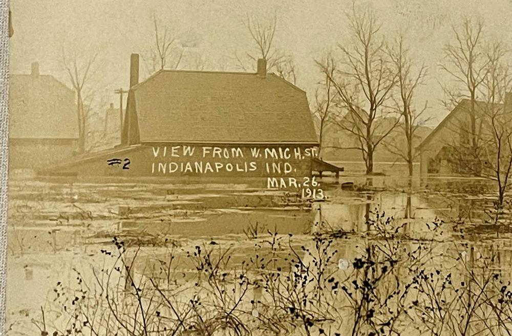
Why do I find this so interesting? We still got flooding in the Indianapolis area, but nothing close to the severity seen north of us (or in 1913). One measuring station showed a crest of a touch over 21 feet – still about 10 feet above flood stage, but about a foot shy of the old record. That quarry turned out to be an inadvertent safety valve that took 9 billion gallons out of a raging, record-breaking flood and kept a bad situation south of it from being far worse. So, while areas north of the quarry (and Martin Marietta) suffered terribly, areas to the south of it were largely spared the worst by little more than a fluke of luck.
- Technically, the White River consists of two forks – east and west. The West Fork is the larger of the two, and is generally identified simply as “The White River”, while the other is usually called the East Fork of the White River. Muncie, Anderson and Indianapolis are all on the primary (west fork) branch of the river. ↩︎
- All river crest measurements and related data from the National Weather Service at https://www.weather.gov/ind/august2026flooding ↩︎
Lede photo from WTHR News, Indianapolis
 J. P.'s Blog
Thanks for the shoutouts! I was just talking about the MM quarry with a member of the Irving family who owns many around here (including one behind my workplace).
I’m kicking myself for missing the adapter needed to connect my drone to my new phone. Those aerials were amazing!
LikeLiked by 1 person
I know – I have been compulsively staring at some of those aerial videos for several days now. Those guys running the quarry have a real job ahead of them, and I read that Carmel officials said it was down to a matter of hours before the river would have broken through on that course permanently, so they were lucky to get the flow stopped up in time.
LikeLiked by 1 person
That’s interesting how the quarry served as a safety valve. I read about how urban planning for sea level rise here on the East Coast builds in a similar concept by utilizing park areas that during high tides can effectively serve as holding ponds for flood waters. Redesigning the urban landscape to incorporate such design features is a big job…but one that is unavoidable over the course of the next decade. Engineering and building such things is absolutely a growth industry.
LikeLiked by 1 person
The ironic part is that this was completely accidental! It will be interesting to see the future relationship between M-M and area planners. They might have vastly different ideas on how things should be designed.
LikeLike
Interesting that the quarry ended up preventing an even bigger flood. Around here, the high-water mark for floods remains the 1972 disaster caused by Hurricane Agnes.
LikeLike
Its amazing the power of water – which we don’t realize until catastrophic flooding occurs.
I lived in the Chicago area for a few decades, and they have a project there called the ‘deep tunnel’ which captures lots of rain water overflow. The system incorporates huge tunnels under the city and suburbs, as well as several quarries and detention basins.
During the same flooding episode you are referencing, an abandoned quarry on the south side was filled to something like 95% capacity – which was around 8 Billion gallons of water. The system is designed to capture rainfall as well as any sewage overflows, and after the rain stops it then can be pumped out and treated before being released into the river. Seems to work well. Of course in your case, Martin Marietta is still using their quarry so that kind of thing isn’t possible – yet.
LikeLike